|
|
|
EASY DAY HIKE 5.3 miles 450' elevation gain
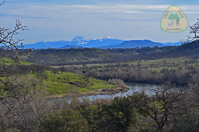
best season: 1:00 drive dogs welcome This hike meanders along a bluff overlooking the Sacramento River, with excellent views of Lassen Peak. You then do a mild climb up to Paynes Creek Point with even more wide-ranging views, including of Mount Shasta (on clear days). You then return to the trailhead via picturesque Perry Ravine. ---------------- There is a pleasant campsite about half way with some tent sites nestled under the Blue Oaks. There is a small water source during the rainy season. Good views may be had from your tent, or stroll up to the Point at sunset for a potentially breath-taking treat. Campfires are allowed with a permit, and there is a good spot for your fire. It has plenty of tent sites (more than a dozen). Recommended camping season is after the weather warms up in Spring, but before it dries up and fire danger increases, probably March and the beginning of April in most years. ---------------- Also, flowers peak in March and early April. This hike is in Sacramento River Bend Area; owned by the public, managed by Redding Field Office of Bureau of Land Management. Backpacking welcomed. Calif. Campfire Permit required for backpacking stoves and campfires. Redding Bureau of Land Management campfire restrictions here What are the peaks visible from the top of Paynes Creek Point? Maps Apr 2021 edition |
 Avenza version
 Adobe PDF version